The financial and regulatory landscape for electric utilities across the United States has reached a critical tipping point. Wildfire liability is no longer just a “California problem” or a West Coast risk. Changes in climate patterns, severe drought, and changing state tort laws mean that electric providers nationwide—from multi-state investor-owned utilities (IOUs) to local municipal networks and member-owned rural cooperatives (co-ops)—face existential threats from utility-ignited fires. This elevated threat situation warrants a transformative shift for utilities operations.
In states like Colorado, Oregon, and Washington, wildfire liability remains entirely uncapped under common-law negligence. Even in states that have aggressively moved to pass legislative “safe harbors” or statutory damage caps—including Utah, Arizona, Idaho, Wyoming, Montana, and North Dakota—escaping multi-million(billion)-dollar third-party lawsuits requires utilities to provide absolute, indisputable proof that they are continuously meeting strict compliance and standard-of-care metrics. Meanwhile, utilities in California continue to operate under “inverse condemnation,” a strict-liability standard where they face 100% of property damage costs regardless of fault.
Faced with these potential multi-billion-dollar risks, utility executives have rapidly deployed a patchwork of legacy tech—such as 360-degree mountain-top camera systems, satellite vegetation tracking software, or wildfire risk simulation tools.
However, relying exclusively on these discrete stacks creates a catastrophic flaw: the real-time operational blind spot. Satellite passes, software models, and mountain-top cameras are fundamentally lagging or reactive. They cannot alert a live asset/equipment failure in progress.
To protect corporate solvency, customer affordability, preserve credit ratings, and safeguard local communities, energy providers must shift from historical software modeling and smoke monitoring to proactive, pre-ignition grid intelligence.
The Gaps in the Current Tech Stack (The Problem)
Many forward-thinking utilities have heavily invested in legacy wildfire systems. While these platforms serve separate purposes for long-term forecasting or post-ignition emergency dispatch, they are entirely unequipped to alert imminent failure or intervene during a rapid grid failure:
- The Satellite Planning Gap
Satellite-based vegetation analysis is a powerful tool for macro-level landscape planning, but it operates on periodic satellite flyovers. It cannot see a tree branch fracturing in a sudden high-wind storm, it cannot detect an active equipment malfunction, and it cannot flag immediate, hour-by-hour physical encroachment on a live line.
- The Theoretical Simulation Gap
Software that models wildfire behavior and weather risk provides excellent theoretical forecasting. However, simulation data does not tell an operator which specific insulator is arcing or which pole is structurally leaning right now. It predicts where a fire might spread, but it cannot alert the spark that starts it.
- The Reactive Camera Gap
Mountain-top cameras are high-tech smoke detectors. By the time a camera identifies a visible smoke plume on a distant ridge, the utility’s equipment has already failed, the ignition has occurred, fire has spread and the utility’s financial liability is locked in under state law.
The Solution: Green Grid Inc. Instant Situational Insights® for Utilities (iSIU®)
To survive extreme weather events, utilities must transition to an advanced Artificial Intelligence of Things (AIoT) infrastructure platform—like Green Grid Inc.’s Instant Situational Insights® for Utilities (iSIU®). Operating directly on the distribution, transmission or substation infrastructure itself, the iSIU® acts as an asset-level shield that isolates risks hours before a crisis begins.
The Nationwide Pre-Ignition Timeline Analysis
Phase | Legacy Tools See (Satellite / Simulation / Ridge Cameras) | What Green Grid Inc. iSIU® Detects | iSIU® Advantage |
1. Environmental Build-Up | Risk Software: Flags a high-risk weather forecast across a broad geographic zone. | Live video and weather data from the right of way with automated alerts for dangerous conditions developing. | 100+ Real time AI-Powered alerts and decision making, not a forecast or model |
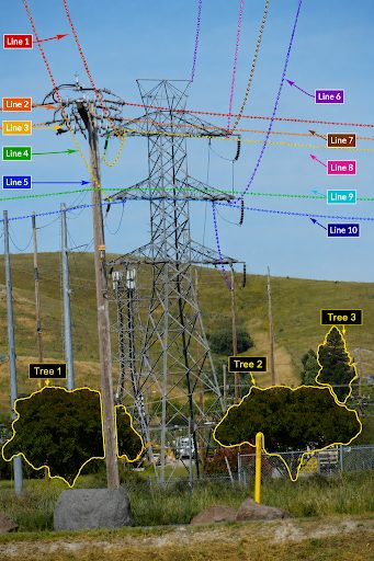
2. Physical Hazard Onset | Satellite / Cameras: Nothing. (Satellites and mountain top cameras aren’t overhead; no smoke exists). | Computer Vision Edge Analytics: Identifies arcs, tree sway, dangerous wire-slapping, safety thresholds are being breached. | Days, min, hours of notice that a specific span is unstable. |
3. High-Risk Encroachment | Satellite Analysis: Missing. (Cannot track real-time dynamic asset failures, human activity & branch breaks). | Continuous Spatial Monitoring: Captures live video proof of a tree limb snapping or blowing into the clearance zone. | Preventative maintenance can be performed. |
4. The Grid Event / Ignition | All Systems: Blind. (No risk model can detect real events on the physical line). | Patented Sensor Fusion Network: Instantly detects the physical movement & drop of a line, pole / tower lean, and the small initial arc flashes or sparks. | Automated multimodal alerts at the span level with precise location before a fire can take hold on the ground. |
5. Post-Event Investigation | Ridge Cameras: Reactive to smoke plume only. (It’s too late) | Ironclad Video Evidence: Provides localized, timestamped video footage capturing the exact cause—whether a utility asset, lightening, or an act of human arson. | Continuous record for root cause analysis for continuous improvement and legal defense and liability protection. |
Why the iSIU® Platform is the Non-Negotiable Standard for Grid Defense
- Millisecond Circuit Isolation (SCADA Integration)
When high-velocity winds whip tree branches into distribution lines, a macro-level risk model cannot protect your assets. Mountain-top cameras and satellite maps cannot stop a physical spark. The iSIU® edge-computing network tracks 100+ unique grid hazard signatures in real time. It catches transformer leaks, hardware degradation, and structural pole lean, enabling operators to automatically trip circuits or deploy Enhanced Powerline Safety Settings (EPSS) to cut power before live sparks hit dry ground cover.
- Replacing Periodic Mapping with 24/7 Touchless Virtual Patrols
Tree-to-line contact remains a primary driver of devastating utility wildfires. Traditional physical line patrols, drone flyovers, and satellite updates leave extensive temporal gaps where hazards go unnoticed. The Green Grid Inc. iSIU® platform provides 24/7 autonomous monitoring for vegetation encroachment, structural shifts, equipment damage and foreign object debris across high-risk spans. This capability gives field crews a localized, predictive maintenance roadmap to trim or remove vegetation before weather events trigger an emergency. This continuous virtual patrol capability along with human ingenuity ensures Electronworthiness® of grids.
- An Ironclad Courtroom Alibi Anywhere in the USA
- In Negligence & Safe Harbor States (UT, AZ, ID, WY, MT, ND): A utility must legally prove it was substantially complying with its Wildfire Mitigation Plan to unlock statutory damage caps or establish innocence. The iSIU® cloud-based dashboard generates an unalterable historical log of risk events, automated alerts, and completed mitigation tasks, serving as the definitive empirical defense against third-party lawsuits.
- In Uncapped Liability & Inverse Condemnation States (CO, OR, WA, CA): To avoid catastrophic credit downgrades or protect against massive third-party subrogation claims, utilities must prevent the spark entirely. The iSIU® platform delivers the exact end-to-end data transparency needed to prove an incident was caused by an external factor—such as human arson or a tree falling from far outside the utility’s legal trim zone or act of god such as lightning strike or volcanic eruption. .
Moving Beyond the Software Checkbox
Macro risk simulations, satellite mapping, and mountain-top cameras are excellent historical or diagnostic or confirmation tools, but they do not solve real-time physical problems on the wire, structure or equipment. For utilities looking to protect their balance sheets and achieve real time ignition risk alerts, relying on a software stack that can only confirm a crisis once it is already terminal or unavoidable is a multi-million (billion)-dollar gamble.
The Green Grid Inc. Instant Situational Insights® for Utilities (iSIU®) platform shifts utilities from fragmented, reactive data monitoring to real-time predictive prevention. In addition, it is capable of dynamic line rating (DLR) for congestion management. The long-term roadmap includes autonomous ignition suppression by sensor connected fire suppression drones before human intervention can occur. The autonomous early suppression of ignition is a crucial capability to prevent electricity-caused wildfires. With all these unmatched capabilities, simplicity and scalability, iSIU® is the most comprehensive platform that is pushing the boundaries of utility asset, vegetation, weather and power demand-derived elevated outage, wildfire, and congestion risk management.